All of us are active transportation users at some point along our journeys. That means we use either walking, biking, a wheelchair, or any other self-powered mode to move from place to place. What I love about active transportation planning is that these projects truly serve everyone in the community. You don’t need a license, vehicle, or money to use your own two feet! In honor of International Walking Day (April 3) and Earth Day (April 22), I think it’s a great time to acknowledge the benefits of walking and biking and—more importantly—identify how planners can make it easier to utilize these modes.
Designing for People
Active transportation projects always have a degree of creativity, because at their core they are about designing the built environment (human-made surroundings) for people. I know that when I’m walking and biking, I want to do it in an area that is enjoyable, pleasant, and where I feel safe. Embedded into our planning decisions is considering human behavior so that we develop solutions around how someone wants to travel. For example, we locate crosswalks where pedestrians want to cross instead of where it makes most sense for traffic flow.
Many of Foursquare ITP’s active transportation projects are in places that have been designed around the car. But I think about how we can transform these communities into pedestrian- and cycling-friendly places. What are the connections people would want to make? Is the public right-of-way attractive? Will bicyclists and pedestrians have interesting things to look at? Is it well-shaded and well-lit? Is the land use in these areas inviting? These are just some questions I consider when planning for active transportation that may not seem obvious.
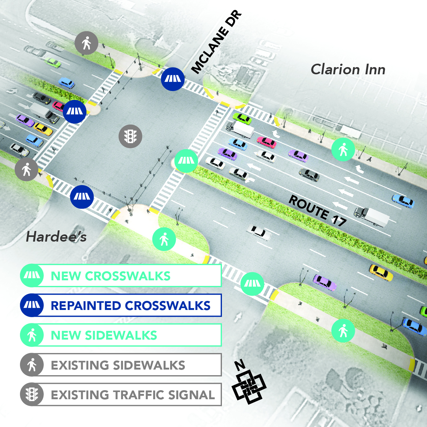
Our work in Stafford County, Virginia highlights how we plan with these questions in mind. The study area consisted of several residential communities split from each other by a busy commercial arterial. We explored what connections were missing, trying to put ourselves in the shoes of local residents to understand how they could better move about the community without a car.
Designing for Communities
We cannot plan for transportation in a vacuum. Active transportation, land use, and urban design are all closely related. Just look outside our office in Center City Philadelphia. The surrounding streets feature wide sidewalks and a bicycle lane. They also feature an interconnected grid of streets, buildings that come straight up to the street, and a lot of street-level activity. All these factors work together to create an environment where walking is the default option for short trips.
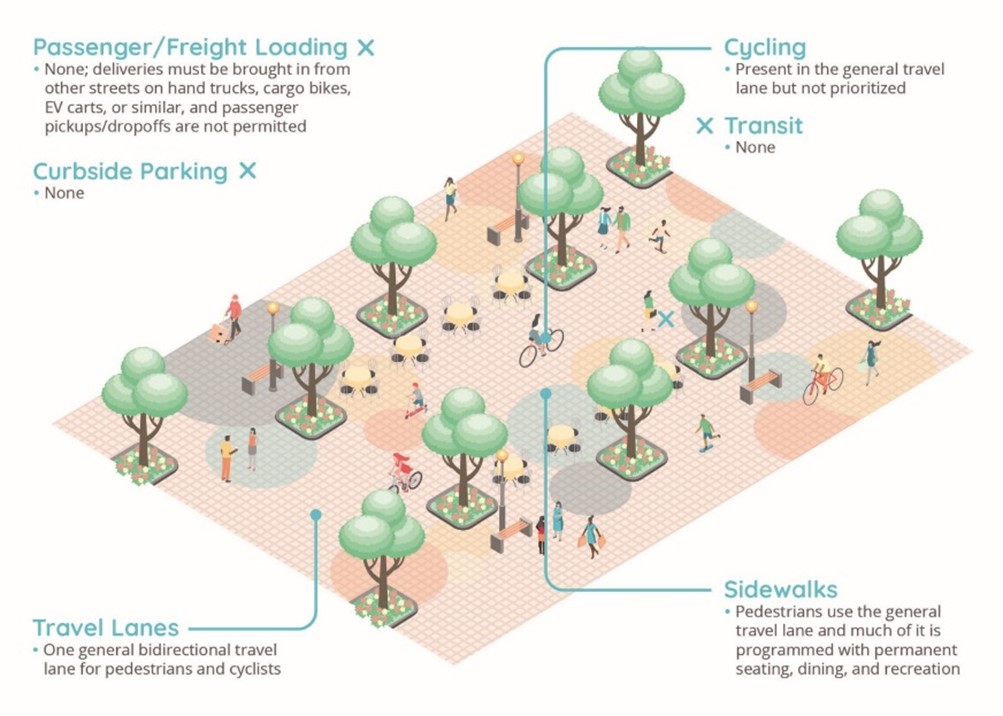
I have been fortunate to work on exciting projects at the intersection of land use and transportation. In 2023, for instance, Foursquare ITP completed the South Downtown Atlanta Transportation Plan. We examined how active transportation and new development can work together to create a more human-scale neighborhood. My team defined a network of street typologies that help to reallocate space from cars to a variety of modes and create new, vibrant public spaces. In each of these areas, designing for walking and biking to be the default mode of transportation—rather than an alternative—was key.
Designing with Data
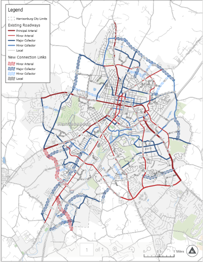
I hope you know by now that at Foursquare ITP, we love data. Our team constantly works on new approaches that use data to quantify and identify active transportation needs. For example, in Harrisonburg, Virginia, we used travel demand and roadway data to help identify missing linkages in the City’s roadway network, creating a street connectivity plan that allows the City to build a denser grid of pedestrian- and bicycle-friendly connections over time.
We’re also supporting statewide active transportation planning in Maryland and Texas, using big data to identify and prioritize gaps in the network. And in Austin, Foursquare ITP is working with Replica data to identify where bike share could most effectively meet travel needs based on the concentration of trip starts and ends under three miles in length. Using big data to design for active transportation helps us visualize where active transportation is most needed so that we plan accordingly.
Designing for Fun!
I can’t forget about another reason we are passionate about active transportation: it’s fun! I think it’s so satisfying to hop on a bike or go for a walk on a nice day. People choose to walk, bike, run, roll, scooter, and hike to exercise, socialize, and explore, not just to reach a destination. At Foursquare ITP, our team practices what we preach, with many of us traveling on foot or by bike.
While people may be apprehensive about changing their travel patterns and modes, giving them opportunities to try active transportation options on a small scale can help lead to big shifts. For example, shared micromobility can be a tool to turn someone into a bicyclist. That’s why many of our bike share plans look at how we can tie into recreational and leisure facilities. Someone who tries bike share one day along a trail is more likely to consider bike share the next day as their mode to the nearby store. Our amazing transportation demand management (TDM) team supports this mission by helping promote and incentivize people to try the active modes we plan for!
I like supporting active transportation planning because it’s a great way to keep people—and the Earth—healthy. So, I hope you’ll check out how Foursquare ITP helps you plan more easily to walk, bike, or wheel your way to your destination to reap all the benefits of walking and biking!